Below are the victim's impact statements that Annette Richards and I delivered to the judge on Friday, March 20, 2015, before the sentencing of William Donald Johnson for his conviction of murder in the death of Phil Richards. Mine was taken largely from
what I wrote in this space several months earlier. Annette wasn't sure she would be able to get through it, but she did and I was incredibly proud of her. Phil's daughter Christine also delivered an impassioned statement about the loss of her father. She is also a very brave young woman whom I am proud to know.
“Sometimes you will never know the value of a moment until it becomes memory.”
-- Theodor Seuss Geisel (Dr. Seuss)
Impact Statement
Reflecting on the death of Phillip Richards
who was killed by William Donald Johnson
by Donald Davidson,
Redlands, Calif.
Good morning, your honor. Thank you for giving me this time to share my thoughts for the record about the loss of our friend Phillip Richards, the kind of person he was and what we endured the days before he died.
I would like to begin by publicly thanking all of the officers of the Riverside County Sheriff's Office’s Cabazon station for their diligence in seeking out the suspect in this crime; specifically Deputy Constantin Ghilici and Investigators Jackie Lane and Randy Thomas for their persistence and dedication in investigating the case and keeping family and friends informed of its progress; and for Deputy District Attorney Kevin Beecham and Victim’s Advocate Karina Meza-Vasquez for their professionalism and compassion for Phillip and his family and friends in bringing the case to trial and for the resulting conviction. And we thank you, your honor, for steadfastly ensuring that the rights of both the victim and the accused were protected throughout the trial.
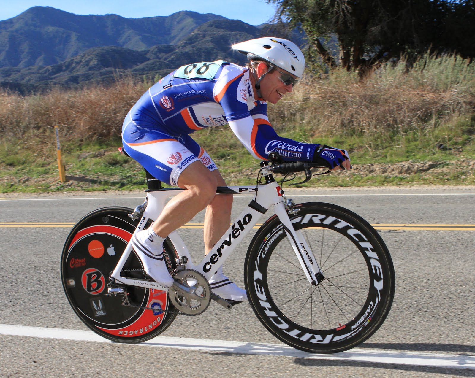
As I said during my testimony in the trial, Phil Richards was my best friend, cycling companion and bicycle road racing teammate for 27 years; and while I am here today to reflect on the impact of his death on me, I also represent hundreds of cyclists he rode with and other friends whose lives he touched. Some of them are here in the courtroom today.
Phil was a small man at five-foot-four, but had the biggest heart of anyone I've ever known. Generous to a fault, he was always giving things to me and to others: homegrown vegetables, bike clothing, bike parts and accessories, bottles of wine, cases of energy bars he found on sale at Big Lots, you name it. I could never leave his house without something in my hands. A few weeks before he died, Phil gave a friend and teammate a $1,000 set of racing wheels just because he needed some.
I can take you to the exact spot on Barton Road between Loma Linda and Grand Terrace where, while riding my bike one morning in 1986, he rode up to me and as he always did with riders he didn’t know, chatted me up: “Where are you from? What do you do? How do you like that bike? What do you think of those wheels?” We had a lot in common: former runners turned racquetball players turned cyclists, young families at home, passions for music and fine wine. We became fast friends.
It's hard to put into words what he meant to me. I estimate we rode bikes together more than 1,500 times and during those thousands of hours together we talked about anything and everything that was on our minds. "Best friend" doesn't do justice to the kind of trust we shared.
We also raced bikes and worked together as teammates in hundreds of road races, where we were dubbed the Everly Brothers -- after the singing duo also named Don and Phil -- as we took turns riding away from the field in an attempted breakaway. Occasionally it worked; mostly it didn't. But it was fun as hell and I was proud to be his teammate and friend.
During the past few years, a series of setbacks for each of us meant less racing together: Phil's surgeries on his shoulder and knee and to have a heart pacemaker installed; my treatment for prostate cancer. Yes, he had a pacemaker installed a few years ago to keep that huge heart beating regularly. No, he didn’t sit on the couch and feel sorry for himself.
Instead, he opted for a new, experimental pacemaker for athletes and worked closely with his doctors to “dial it in” so he could be competitive on the bike. We were training for the 2014 racing season and planned to race the two-man team time trial together at the state championships in May. Sadly, that never happened.
Like nearly every weekend since we met, we did a hard training ride together on Saturday. December 28, 2013, the day before the collision that cost him his life. It would be the last time I would speak with him in person.
He called me that evening and he left a voice mail, which I saved: "Alright, my man, anything left in the tank after today?” he chuckled. “Anyways, what is the plan for tomorrow? Give me a jingle when you get a chance, all right? We'll catch ya. Bye-bye." I called him back later and we agreed we had different plans for Sunday so we struck out separately, which was rare.
On Sunday afternoon, I received a message from his wife Annette, who was very distraught, her voice quivering: “Don, I need you to call me immediately,” she said. “I need you. Call me."
I called her to learn she was on her way to the hospital after the Riverside County Sheriff's office told her Phil had been hit by a car and was gravely injured. When I arrived at the hospital, I learned his condition was very serious: his right side was shattered from the impact of the collision. His right arm, leg and ribs were broken and the extent of his internal injuries was not clear. Because of his breathing tube, he was unable to speak in the hospital that day, but was conscious enough to motion to Annette that the band on his pony tail was bothering him and that he wanted to shift positions in bed.
They repaired his broken leg in surgery that night, but held off on additional surgeries. He was bleeding internally from an artery behind his liver and they didn't want to risk surgery because of the likelihood he would bleed out before they could get to it. They put pressure on his abdomen to reduce the bleeding, but he required several transfusions.
When I got to the hospital the next morning, we learned he coded overnight and the doctor massaged his heart for 15 minutes before he came back. While we were glad he was still with us, that event proved to be the beginning of end because the lack of blood flow to his kidneys caused them to fail. His arms grew swollen like Popeye’s -- nearly as big as his thighs -- from fluid build-up. He never regained consciousness and despite a few flutters of his eyes in apparent recognition of our presence in the early days, his body and his brain slowly shutting down. As far as I know, the last words he spoke were to the EMTs as he lay in the middle of the road after colliding with Mr. Johnson’s car, shattering its windshield and being catapulted into the middle of the road: "Call my wife."
During his 13 days in the hospital, family and friends came from near and far and kept a constant vigil. Phil's condition was like a roller coaster physically, and we all rode it with him emotionally. Daily kidney dialysis was required as well as surgeries to remove sections of his bowel destroyed in the collision. Because his family is here, I will spare the court additional medical details of his last few days, but suffice it to say is was not pretty.
It was decided to take him off the sedatives to observe his brain function and the news was not good: he was diagnosed with diffuse axonal injury to his brain. We Googled it on our phones in the waiting room and our hearts sank when we read this:
Sudden acceleration and deceleration of the brain that can occur in an auto accident causes the lesions that are responsible for unconsciousness, as well as the vegetative state that occurs after a severe head injury.
His prognosis for living was not good; and if he survived his quality of life would be dismal.
During those days, I kept friends aware of his condition through e-mail and Facebook, trying to be positive but also being honest about the gravity of his situation. Annette bought a portable CD player and brought some of Phil's classical music favorites to play in his room. We were hopeful, but resigned to the likelihood we would lose him soon. Annette had the “do-not-resuscitate” discussion with the doctors.
I arrived at the hospital a few minutes after 5 p.m. on January 11, 2014. As the double doors to the ICU opened, Annette was walking down the hall toward me and looking very distraught. "He's gone," she said and sobbed in my arms. I also cried many times that day and many times since. Mozart was playing in the room when he took his last breath. I went into the room and said my good-bye and joined Annette and her friends outside the hospital where we called loved ones to break the news. I called Investigator Lane and they re-arrested Mr. Johnson the next day and charged him with second-degree murder.
After news of his death broke, the Inland Empire Biking Alliance set up a white "ghost bike" near the site of the collision in Calimesa and on Saturday, January 25, we held a memorial bike ride from Redlands to the site for a moment of silence, then on to a park in Beaumont for a celebration of his life. More than 250 cyclists attended the ride, escorted by the Redlands and Beaumont Police Departments, and many more people joined us at the park. The support of family and friends was incredible. Annette’s co-workers went above and beyond in planning the event and a gofundme.com campaign raised more than $8,000 to help with her expenses.
Our friend and fellow racer John McKee arranged for the masters bike race in Brea on February 9 to be dedicated to Phil. He and another rider Rick Swanson found a source and provided memorial wrists bands for us to wear at the race and which I am wearing today. I was honored to lead a neutral lap at the beginning of the race in Phil's honor with our good friend John Rubcic and Bicycling Hall of Fame member John Howard, who came to the race solely to honor Phil. I walked past the place where we parked every year to get ready for that race. It was hard to believe he would never join me there again.
Along with friends and teammates Steve Mera and Bob Estupinan, we hatched an idea to create a new cycling team called PR Velo. The mission of PR Velo is simple: ". . . to honor the spirit and preserve the memory of our friend and brother in cycling Phil Richards." We have nearly 50 members who wear this jersey, which contains symbols we chose to represent the things he loved in life. John Rubcic wore it at the National Masters Cycling Championships in September of 2014, where he won and race and wore it on the top step of the podium as national champion. Phil would be as proud of John as we are.
In December of last year -- near the anniversary of his crash -- PR Velo held another ride to the site in Calimesa. The ghost bike is gone, but we dedicated that day a memorial monument at the site that Bob Esupinan built to honor Phil. At the beginning of this racing season, Rick Swanson -- who was himself very seriously injured by a negligent motorist last September -- put up a cash prize in Phil’s honor at a race series that is held on Ontario, and we learned last week that the masters race at the Redlands Bicycle Classic next month will be designated the Phil Richards Memorial Criterium. One of the most prestigious and the longest-running stage race in the U.S., the Redlands Classic has been going on since 1985 and Phil raced it nearly every one of those years.
Many people have said Phil would be pleased with the idea of the PR Velo team, the jersey and the things we’ve done to honor him. I don't know about that. I wish instead he were here with us today to continue his life and enjoy the things he loved. As we think about Mr. Johnson’s actions and his future, it’s easy to think, “Phil Richards was 64 years old, he lived a long, full life - the loss was not so great.” Instead, we should reflect on the incredible sacrifice Phil made. His death, and the unbelievable -- miraculous, if you will -- timing that led to Office Ghilici’s seeing Mr. Johnson’s vehicle under the car cover that day means that Mr. Johnson will not be on road and able to kill others -- himself included -- for a long, long time. I hope that while he is incarcerated Mr. Johnson will reflect on the fact that Phil Richards likely saved his life. Phil gave him the ultimate gift. I also hope that while Mr. Johnson is incarcerated he will reflect on the character of the man whose life he took and when released, will engender Phil’s principles of giving to others and loving them without judgment.
About a week after Phil’s death, my wife Deena and I went to see Annette and she said to me, “Hold out your hand.” I extended my right hand and she took a ring from a box put it on my ring finger, asking, “Does this fit?” It is a ring she gave Phil for his birthday shortly before he died and yes, it did fit -- and I now wear it proudly every day. It has two outer rings that spin around six sets of gears resembling the pulleys of a bike derailleur. I spin the rings every day and think about riding with Phil and how much I wish I could do it again.
Phil's influence on everyone who knew him is undeniable and without his presence in our lives we would be a very different people than we are today. I speak for myself and all of those who knew him when I say, “We miss you, brother.”
Thank you, your honor.
Impact Statement
by Annette Richards,
Beaumont, Calif.
Good morning, your honor. On December 29, 2013, Mr. Johnson made a very poor decision that forever changed life for my husband Phillip, me, our family as well as our friends -- and not to mention his own. I am here to let you know how this situation has had an impact on my life. I am struggling and faced with how this has affected my life in every single way possible. I am completely heartbroken by the loss I have been challenged with. My husband and I were married for 15 wonderful years and were still incredibly in love with each other.
I am faced with trying to figure life without Phillip. He was my best friend. Phillip had just retired in 2012 and our relationship was getting stronger than it ever was. We were making plans for the future to travel and enjoy life together; now that has all been crushed and I am forced to completely rearrange my whole entire life as a middle-aged woman. Our family is suffering an incredible loss with Phillip no longer here. I will no longer get to wake up in the morning and have my husband kiss me on the lips and tell me how much he loved me and beautiful I am to him.
Instead of a normal peaceful afternoon of coming home and spending time with my husband, on December 29, 2013, I received a phone call from an officer telling me to rush to the hospital; then on January 11, 2014 -- 13 painful days later -- my husband was gone forever. Ultimately, your honor, our lives have been forever changed with the tragic loss of Phillip and no words can truly express all of the feelings and emotions felt by all of us. I truly hope to get a sense of release and some closure from the time that will be served. It will not ever relieve the sadness and heartbreak felt by so many.
Thank you for letting me have a moment to speak to you.