This shot of peeling orange tree bark was taken in an abandoned, dying grove in northeast Redlands. It reminds me of a time when we had seeming endless groves of citrus trees in this town. Now, we have Citrus Plaza -- a giant shopping complex with seemingly endless blacktop and concrete. I much prefer the trees. You can view the original image at SmugMug.
I haven't posted anything here for quite a while, and rather than subject my friends to my usual "croc" of useless drivel, I'm stealing an idea from my good friend Andrea Anthony -- Photo of the Day. Hopefully, it will inspire me to expand and improve my SmugMug gallery. Thanks for the inspiration, Andrea!
Last year, when I rode my bike to South Fork, hiked to the peak of San Gorgonio Mountain, then rode home (all in one day), most of my friends told me I was crazy. Given that most of my friends are a whole lot smarter than me, I should probably listen to them and stop this nonsense. Not!
This year was no exception as I made it my goal to do the 26-mile Nine Peaks Challenge on my birthday, which conveniently fell on a Saturday and on the summer solstice, the longest day of the year.
The Nine Peaks Challenge is a rite of passage for local Boy Scouts, who usually do it in two or three days of backpacking and camping. My goal was to do it in one day and earn the $4.95 patch they sell at the Mill Creek Ranger Station that says: "I climbed nine peaks." Here are the peaks, in order, from east to west:
Mount San Gorgonio - 11,500' Jepson Peak - 11,205' Little Charlton Peak - 10,696' Charlton Peak - 10,806' Alto Diablo - 10,563' Shield’s Peak - 10,701' Anderson Peak - 10,864' San Bernardino Peak East - 10,691' San Bernardino Peak - 10,649'
Well, I did manage to do the 26 miles in one day, but it's going to have to be recorded as a "do-over" because -- much to my disappointment -- I couldn't find routes to all the peaks. I have the topo map the Forest Service sells and I've been to San Gorgonio and San Bernardino peaks and they're pretty well marked, but I haven't been to all the others. Before I made the trip, I asked the Forest Service ranger who runs the Mill Creek ranger station if the routes to each of the peaks were clearly marked. The ranger's response was, "There aren't any signs, but you shouldn't have any problem finding the route off the main trail."
Unfortunately, I didn't see a single trail to any of the peaks. I almost missed San Bernardino East Peak a week earlier and was able to bag it only because I noticed a pile of rocks with tree limbs poking out of it and climbed it to find the register box.
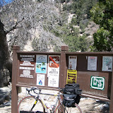
Weather for the day was absolutely perfect. Low clouds filled the valley, but when I left the house at 5:45 a.m. and drove up Hwy. 38, I was quickly out of the haze and saw clear blue skies above the mountains to the east. I parked my truck at Angeles Oaks and rode my bike back down Hwy. 38 to the Forest Falls turnoff and up to the Vivian Creek trailhead, stopping at the Forest Home Conference Center to fill my three-liter Camelback and two ceramic-lined, aluminum-coated one-liter bottles (bought at Joyce's store in Vancouver -- I love those bottles!). The entire ride, including the stop for water, took about an hour. I changed clothes, locked the bike to a sign post and set out toward San Gorgonio peak at about 7:45 a.m. I would drive back to get my bike after finishing the hike in Angeles Oaks.
Here is a screen shot of the GPS data view of the ride portion of the morning, taken from the Garmin Connect website (click on the image to see a larger version):
I had been only as far as High Creek on Vivian Creek Trail and that was about 40 years ago, so I wasn't sure what to expect, except for steepness: it climbs from 6,000' to 11,500' in 8.7 miles. I made trips up the trail on April 19 and April 26 and had to turn back because of the snow. The only remaining snow on this day was near the peak and the hike was incredible! I recall saying to myself over and over: I am so blessed to be here, to be able to take these steps, breathe this air, hear these natural sounds and see this view.
I told myself I was going to limit my photography to only a few shots because I was venturing onto several new sections of the trail and wanted to make sure I could make the entire 26 miles before dark. I did manage to get off a few shots on the trail (click on these photos to see a larger version), along with a short video from the top of San G.
This is looking south at the Yucaipa Ridge, which looms above Forest Falls:
This is another view looking south with Mt. San Jacinto in the background:
Here is a view of The Tarn, the ridgeback-shaped bump on San Gorgonio that is prominent when you view the mountain from the southeast (e.g., Beaumont). This is also the end of Vivian Creek Trail:
Unlike last year, when I got to the peak of San Gorgonio and it was complete socked in and I got hit with hail and rain, this was the view I was hoping to get. It was incredible! I was also very cold and windy (as you'll see and hear in the video). The mountain behind the flag is Mt. San Jacinto:
At about 11,000 feet my hands got really swollen and I was concerned about edema, so I kept them above my heart, frequently in my armpits to warm them or holding my backpack straps. That helped, but I was still very uncomfortable and standing up in the wind at the peak was not pleasant. I was barely able to move my fingers when I signed the register, but here -- for all posterity -- is a record of my time at the highest point in Southern California on my 59th birthday:
As I left the peak, I scoped out the area to the west where I was headed. The mountain in the far distance beyond the cloud-covered valley is Mt. Baldy. The ridge with three peaks in the near distance (beyond the barren landscape of San Gorgonio) is the San Bernardino Divide. After going over those peaks, I would drop down into Angeles Oaks:
I consulted the map in order to make sure I made it to the next peak, Jepson Peak. It looked easy on the map, but as I went along the trail I saw no sign of a route to another peak, so I pressed on. As I kept moving on the trail, it was apparent that I was passing alongside the other peaks, but saw no route to the top and didn't have time to venture into unmarked areas, hoping to blaze my own trail to the top.
Eventually, I made it to San Bernardino East Peak, which offers a spectacular view. From there, the trail was not very well defined and I lost it on the way to San Bernardino Peak. I've read many books about hiking and what to do when you get lost and I began to feel the sense of panic and urgency set in. I kept my head, noted the direction I came from and crisscrossed the ridge to try to find a hint of a trail, but had no luck.
Finally, I heard the sound of voices and was really lucky that a group of four or five hikers passed along the trail about 100 yards down the mountain from my position. Relieved, I soon found myself on the familiar trail from Mt. San Bernardino to Angeles Oaks. I arrived back at my truck at about 6:30, meaning the hike took around 10 hours and 45 minutes.
Below is the GPS view of the hike portion of the day (click on the image to see a larger version). As you'll see, there is a straight line from San Gorgonio to a place about two miles west on the trail. When I got to the peak of San G, instead of hitting the lap button to mark my time, I hit start/stop and didn't realize it until about 45 minutes down the trail. Garmin Connect's mapping software drew a straight line between the stop and restart points and doesn't include that time or distance. I also question their calorie calculation. I think it was at least twice what they estimate. It sure felt like it!
My time from the parking lot in Forest Falls to the San Gorgonio peak was 3:45, which is more than 2.3 miles per hour -- on a steep climb, no less. I'm really excited to know it can be done so quickly and plan to do it again this summer to see if I can improve my time. I'll return on Vivian Creek Trail in order to have more time for photography.
It was a spectacular birthday and a great way to say good-bye to a beautiful spring and hello to what portends to be an equally splendid summer. Whatever you do, make time to do some of it outdoors!
I've posted a lot about Chris's Air Force awards and realize I'm seriously past due on recognizing Dean's accomplishments. It wasn't that long ago that, after an arduous stint as a student, he was graduating from Art Center College of Design and trying to figure out what he was going to do with his BFA degree in graphic design.
After a lengthy time living in Vancouver, B.C., with his wonderful girlfriend Joyce and trying diligently to find work in Canada, he realized he was in the proverbial Catch-22: as an American, he couldn't get a job without a work permit; and without a work permit, he couldn't get a job offer. To everyone's dismay, it was clear he needed to find work south of the border.
Well, it couldn't have worked out better. The distinction associated with his Art Center degree, along with a strong portfolio of student, pro bono and paid professional work, earned him the attention of an outstanding company in Burlington, Wash. Dri-Eaz Corporation was the perfect fit: the one-person graphic design department needed to grow to accommodate the acquisition of new companies and products, and Dean had the chops to take them to the next level. (And Bellingham, where he lives, is only about an hour from Vancouver.)
While other companies across the country are struggling with layoffs and cutbacks, Legend Brands (the brand that now includes Dri-Eaz and other new products) is flourishing. And Dean is at the leading edge of the marketing of those brands. He designed the graphic at the top of this page (click on it to see the full-size version), along with the Sapphire Scientific logo that is part of it. (Notice the hexagonal gem that's inside the SS logo - great stuff!)
As he pointed out during his visit home last week, the company's demographic doesn't change very much from year to year, not does the marketing. As a result, his work isn't the kind of flashy stuff you'll see getting awards at graphic design competitions across the country. But he gets my award for creativity, consistency and for landing a great job with a great company with great benefits.
I realize how redundant it is for me to say this, but yesterday was another perfect day in the San Gorgonio Wilderness. I've ventured up Momyer Trail four or five times this summer and it's become one of my favorites. It offers a little bit of everything in just the three miles before the wilderness boundary: cacti, yucca, a variety of flowers of all colors, thick oak, tall pine and beautiful views of the valley below. It's a steep climb in spots, but the trail surface is good -- much better than the loose rock of Vivian Creek Trail a couple of miles east.
In previous weeks, I've veered to the right after the trail divides and taken Falls Creek Trail to Alger Creek, Dobbs Camp, Plummer Meadow and the trail's end at Dollar Lake Saddle. (Click to view the photos.) Yesterday, I decided to take Momyer Trail all the way to the top of the San Bernardino divide, then head west toward San Bernardino East Peak. (Click to view the photos.)
My friend David Money Harris's books and the trail maps warned me that Momyer Trail is not maintained and there were many spots where I lost it and had to do some searching. There are numerous trees down over the trail and from 8,000 feet to 9,000 feet the brush is thick and long pants are essential to keep the thorns at bay. I wore jeans and still came home wounded, albeit mildly.
Almost without exception, this summer's hiking has been fraught with problems with my footwear. The Salomon trail running shoes I bought at REI last year are really comfortable -- until I get about mile threes into an uphill climb, when the skin on my left heel breaks loose. No matter what I do, I get a blister there. It's the result of a misshapen heel from the surgery I had in the 80s to repair my ruptured achilles tendon.
As a result, I tried wearing my Asics running shoes. They fit great and I never had a problem with the left heel, but I wore a hole in the right shoe that led to blisters between my right toes. The solution? Wear the left Asics and the right Salomon:
This worked great, unti I wore a hole in the left Asics shoe, too; so I took them to the local shoe repair store last week. Because they won't be done until tomorrow (Monday), I opted for the Salomons yesterday, along with a special blister bandage for my left heel. Well, that worked well for the first five miles, then the skin broke loose again. I was tempted to head back, but I put up with the pain until San Bernardino East Peak, where I changed the bandage.
It was definitely worth it because the view from the peak was incredible. The valley was socked in with "June Gloom" clouds, but at 10,691 feet, it was spectacular: a 360-degree view of the area and a beautiful vista from the San Bernardino Divide to the Yucaipa Ridge:
All of this hiking is leading up to next week's big test: the Nine Peaks Challenge. I've been planning on this for a year, so I hope I make it. (If I don't, they'll have to helicopter me out because I'm not taking a sleeping bag.) While I'm still not sure which route I'll take, I'm committed to earning the $4.95 patch they sell at the Mill Creek Ranger station that says, "I climbed the nine peaks." It's 25 miles and I'm hoping to complete it in under 10 hours, but -- as always -- it depends on how much time I spend with the camera.
It will be my 59th birthday and summer solstice will occur at 10:46 p.m. PDT, meaning it will be the longest day of the year in the northern hemisphere. Hopefully, I won't need all that daylight for the hike, but like all good pagans, I'll be celebrating the solstice by doing it outdoors.
Well, he did it again. Chris won another award! This time, it's the Jimmey Morrell Award for the 50th Operations Group Standardization and Evaluations Division. Yep, his dad is plenty proud. Here is a video of the announcement at the ceremony:
I was saddened to read the obituary in today's Los Angeles Times about Debora Digges, the brilliant poet whom I met when she visited Claremont Graduate University to accept the Kingsley Tufts Poetry Award in 1996.
She was a warm, humble person with an inviting smile whose writing had a profound effect on me. When the Tufts award judges announced her selection, I immediately bought a copy of her book "Rough Music" and devoured it. It had it all -- joy, despair and a keen perception of the frailty of our existence and of relationships. Her spirit was a like a beacon and she was an inspiration to me to write.
I read in the Los Angeles Times a few months ago that she was going to read her poetry in Pasadena. I wanted to go, but had a conflict and wish now I had made the time. Now she is among those many writers I admire who chose to take their leave from this life: Brautigan, Sexton, Foster Wallace. She will be missed, but her words and her spirit will live on:
Rough Music by Deborah Digges
This is how it’s done. The villagers surround the house, beat pots and pans, beat shovels to drain spouts, crowbars to shutters, rakes raining rake tines on corrugated washtubs, or wire whips, or pitchforks, or horseshoes. At first they keep their distance as if to wake you like blackbirds, though the birds have long since fled, flown deep into the field. And for a while you lie still, you stand it, even smile up at your crimes accompanying, each one, the sunrise stuttering across the ceiling like the sounds within the sounds, like lightning inside thrum-tink, woman-in-wood-shoes-fall- down-wooden-stairs, like wrong-wrong inside rung-rung, brick-smacking-brick housing ice-breaking-ice- breaking-glass . . . I mention this since this is what my dreams are lately, rough music, as if all the boys to women I have been, the muses, ghost- girls and the shadows of the ancestors circled my bed in their cheap accoutrements and banged my silver spoons on iron skillets, moor rock on moor rock, thrust yardsticks into the fans. Though I wake and dress and try to go about my day, room to room to room they follow me. By evening, believe me, I’d give back everything, throw open my closets, pull out my drawers spilling my hoard of dance cards, full for the afterlife, but my ears are bleeding. I’m trapped in the bell tower during wind, or I’m the wind itself against the furious, unmetered, anarchical applause of leaves late autumns in the topmost branches. Now the orchestra at once throws down its instruments. The doors in the house of God tear off their hinges— I’m the child's fist drumming its mother’s back, rock that hits the skull that silences the martyr, or I’m the martyr’s tongue cut out, fire inside fire, clapper back to ore, ore into the mountain. I’m gone, glad, empty, good riddance, some shoulder to the sea, the likeness of a wing, or the horizon, merely, that weird mirage, stone- skipping moon, the night filled up with crows. I clap my hands. They scatter, scatter, fistful after fistful of sand on water, desert for desert, far from here.
Unlike last week, when I snoozed with the cats after breakfast, wimped out and drove to Forest Falls to hike up Vivian Creek Trail, today I saddled up my Litespeed and rode the 17 miles to the trail head. Laden with the customary trunk rack and saddle bags on the bike, along with the Camelback back pack with three liters of water, the ride was really hard, but I made it in under two hours.
I locked the bike to a wooden post behind a sign at the trail head and facetiously asked the Forest Service ranger who was checking for Adventure Passes (the $5 parking permit autos are required to have) if I needed one. He looked at my bike and said, "If you did that after tomorrow, I would cut the lock and impound it. I have to paint those posts tomorrow."
I was nonplussed. I told him the cable was wrapped in plastic and wouldn't damage anything, but he wasn't buying it. "How would you like it if a stranger locked their bike to your front door?" I realized that I was on his turf and did something that he took personally by possibly scratching "his" sign post.
"If you saw my front door, you would realize it wouldn't bother me," I said. He laughed and the ice was broken. He let me slide and said he would look into getting a bike rack. "A lot of people ride up here," he said. "But in my 20 years of working in this area, no one has ever parked their bike and gone into the wilderness." Well, there you go.
Just like last week, the weather was perfect and the hike was beautiful. I hoped to make it to High Creek, but ran out of time and trail -- the snow covered a lot of it at 8,500' and beyond. Maybe next time. The best part was (unlike last week), I didn't have any problems with my shoes. Last week, I got a painful blister about a mile and a half in and it was killer. This week, I opted for my running shoes and they were SO much more more comfortable than the trail running shoes that tore up my heel last week.
I also feel like I got my hiking legs back. I felt so good I ran several portions of the trail. I think next time, I'll cut out the ride, get an early start from Forest Falls and aim for San Gorgonio Summit. I can't wait for June 20 and the Nine-Peaks Challenge. It will be awesome!
Click on the image below to see a few photos from the day:
My goal on this day, Sunday, April 19, was to ride my bike to Forest Falls, lock it to a tree and hike half-way to San Gorgonio Peak via Vivian Creek Trail (about 8.5 miles, round trip). I awoke feeling really good and without any muscle soreness from the big ride to Big Bear and Crestline the day before. I had breakfast, a couple of cups of coffee and read the Sunday newspaper.
After I made the bed, it beckoned me, so I flopped on my back and the cats joined me -- Gracie stretched out across my legs and Suzy cuddled beside me. An hour or so later, I looked at the clock and realized the bike ride portion of the day was not going to happen and ended up taking my truck to Forest Falls. What a wimp.
I had not been very far up Vivian Creek Trail since the 70s, when I pack-packed to High Creek with college fraternity brother Adam Morales (yes, Ruth, your Adam Morales) and slept overnight. A couple of stupid college kids, we lit a campfire (against all the rules) and were lucky we didn't burn down the forest. We froze in our light-weight sleeping bags.
This day, however, was incredible. The weather was once again perfect -- in the 70s all afternoon. There were patches of snow all around, including portions of the trail, which made a few sections a little dangerous where the trail was on the edge of a steep slope. It made for some wonderful photos and video, however. I went about four miles up the trail in two hours -- from 6,000 feet at Forest Falls to about 8,500 feet. The four miles back took about 90 minutes. The first mile after crossing the river is very steep.
Some of the "better" photos from my Kodak pocket camera are available at my Picasa Web site. Below are two short videos I posted on YouTube. The first one shows water striders floating across the surface of a pool of water and occasional bubbles of methane seeping up from the decaying plants at the bottom. The bubbles get quite intense at the end. The second video is of a stream that was mostly concealed by snow, but visible in patches where the snow was melting. Turn up the sound -- it's very soothing and peaceful. No machines!
I was really excited to see two Mourning Cloak butterflies on the trip. When I was a kid, I would watch them as caterpillars feast on mulberry leaves in my backyard, then wrap themselves in their chrysalises under the eves of the house and emerge later as these beautiful, shiny butterflies with golden trim on their wings. I don't see them in the valley anymore, so it was like a visit with old friends.
This was a short warm-up for many hikes to come as I prepare for the Tour of Ten Peaks on June 20. I can't wait for the next one!
Because I've been so busy trying to keep up-to-date with friends on Facebook, I've been remiss in posting here, so here's a brief note about my bike ride yesterday, which was epic. At 127 miles and 19,849' of climbing, it was definitely the biggest day on the bike I've ever had. It was also one of the best -- the weather was absolutely perfect (70 degrees in Lake Arrowhead) and a mild Santa Ana wind made the view of the San Bernardino Valley spectacular.
My friend and Citrus Valley Velo racing teammate Dana Van Stee, who is training for the challenging Breathless Agony ride May 2, joined me for the first portion from Redlands to Onyx Summit. Dana's been getting really good results in his second year of racing this year. It was nice to have some company on the road. He turned around at Onyx Summit and returned to Redlands while I headed into Big Bear Lake and a few points beyond.
There's not much else to say, except to share a few photos (including a GPS-based map view of the route) and say, "What else are you doing to do on a perfect Spring day?"